Up To 4 Million Texans Without Power as Electricity Grid Collapses and Wind Turbines Fail

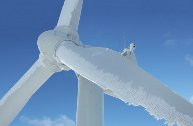
Forty percent of Austin residents are without power, and up to a total of four million Texas residents are suffering under extreme cold conditions as the state power grid is overwhelmed.   Making matters worse, a shortage of natural gas combined with failures of most wind turbines due to ice and freezing temperatures have dropped power generation.

TEXAS – Nearly 200,000 Austin Energy customers woke up without power Monday and were not expected to get it back until Tuesday — possibly late in the day — because of a so-called rotating power outage that didn’t rotate, leaving parts of the city in the cold and dark.

The outages began in the middle of the night, leaving swaths of neighborhoods without electricity, as already freezing temperatures dropped into single digits during an extraordinary winter storm that has raised questions about the city of Austin’s and the state’s ability to handle such an event. (read more)

The Houston Chronicle reports: […] “Natural gas supplies for electric generation are already strained in the winter, the peak season for gas used for heating, adding pressure to supplies used to generate electricity.”

(more…)

Hurricane Zeta Landfall Imminent – Southeastern Louisiana Landfall – Storm Surge Warnings: Louisiana, Mississippi and Alabama…

Fast moving Hurricane Zeta is approaching the southeastern gulf region of Louisiana. Currently traveling over 20mph and expected to increase in forward speed Zeta is carrying winds near 100mph and pushing a dangerous storm surge along the coastline. Residents in the southeast Louisiana, Mississippi and Alabama coastal areas should be prepared.

[Hurricane Center] the center of Hurricane Zeta was located near latitude 27.9 North, longitude 91.1 West. Zeta is moving toward the north-northeast near 20 mph (35 km/h). A faster north-northeastward motion is expected through tonight followed by an even faster northeastward motion on Thursday and an east-northeastward motion early Friday.

On the forecast track, the center of Zeta will make landfall in southeastern Louisiana this afternoon. Zeta will then move close to the Mississippi coast this evening, and move across the southeastern and eastern United States on Thursday.

(more…)

Prayers Answered – No Deaths During Hurricane Delta, But 500,000+ Without Power…

Hurricane Delta posed a particularly dangerous threat to Louisiana as much of the exact same area was previously hit by Hurricane Laura just six weeks ago.  With massive amounts of debris from Laura still in the cleanup process Hurricane Delta was poised to deliver a troubling double-whammy.  However, that said, first responders and state officials are saying there were no fatalities from Delta – Prayers Answered.

[Via ABC] Hurricane Delta, now a tropical depression, made landfall near Creole, Louisiana, on Friday evening, with nearly 11 million people in the storm’s path. More than 600,000 power outages were reported across Texas, Louisiana and Mississippi early Saturday afternoon as the storm’s remnants moved further inland.

Delta is now expected to move across western and northern Mississippi before heading into the Tennessee Valley tonight and Sunday. (more)

Material stuff can be replaced, people cannot.   Now the incredible heroes from across the United States will move in to begin restoring power. Massive numbers of power crews are working to rebuild the grid; tens of thousands of tons of debris being removed. [Much of what is now called “debris” represents the cherished belongings of thousands of lives.]

Now it’s time to try and restore some sense of normalcy for those who have been impacted, and commit to a long-term rebuilding process. Stay strong. Thousands have staged. Help is on the way…

(more…)

Hurricane Delta Approaches Texas/Louisiana Gulf Region – Landfall Expected Later Today…

Hurricane Delta is a cat-3 storm with sustained winds near 115 mph, as it approaches the Louisiana coastal area. Residents in east-Texas and Louisiana should pay close attention as the storm is expected to make landfall later this evening.

Hurricane Center – At 1000 AM CDT (1500 UTC), the center of Hurricane Delta was located near latitude 28.0 North, longitude 93.8 West. Delta is moving toward the north near 13 mph (20 km/h). A turn toward the north-northeast is expected this afternoon, followed by a northeastward motion during the day Saturday.

On the forecast track, the center of Delta should make landfall along the coast of southwestern Louisiana later this afternoon or this evening, and then move across central and northeastern Louisiana tonight and Saturday morning.

Maximum sustained winds are near 115 mph (185 km/h) with higher gusts. Delta is a category 3 hurricane on the Saffir-Simpson Hurricane Wind Scale. Slow weakening is expected before landfall, with rapid weakening expected after the center moves inland.

(more…)

Hurricane Delta Moving Into Gulf of Mexico – East Texas and Louisiana on Alert…

Hurricane Delta is moving into the southwestern Gulf of Mexico this afternoon.  The current forecast from the NHC puts Delta toward the East-Texas and Louisiana coastline this weekend; however, these forecasts are early and everyone on the coastal gulf should keep an eye on this storm and watch for updates.

(NHC) […] At 100 PM CDT (1800 UTC), the center of Hurricane Delta was located near latitude 21.8 North, longitude 88.8 West. Delta is moving toward the northwest near 17 mph (28 km/h). A northwestward motion with a reduction in forward speed is expected over the next 24 hours. A north-northwestward motion is expected by late Thursday, and a faster northward to north-northeastward motion is forecast on Friday and Friday night.

On the forecast track, the center of Delta will move over the southern Gulf of Mexico this afternoon, be over the southern or central Gulf of Mexico through Thursday, and approach the northern Gulf coast within the hurricane watch area on Friday.

(more…)

Hurricane Sally Moves Inland – 80mph Winds w/ Massive Rainfall Over FL Panhandle and Alabama

Hurricane Sally moved over the coast near Mobile Alabama as a category two storm and continues to slowly move inland today.  According to the National Hurricane Center the storm still holds strong hurricane force winds around 80mph as it brings massive rainfall into the region.   Severe flooding is the primary concern as Sally moves inland.

Sally remains a very dangerous storm as she travels NE through Florida, Alabama and into Georgia.  Widespread power outages are a predictable concern across the region.

At 1000 AM CDT (1500 UTC), the center of Hurricane Sally was located by NWS Doppler radar and surface observations near latitude 30.6 North, longitude 87.4 West. Sally is moving toward the north-northeast near 5 mph (7 km/h), and a north-northeastward to northeastward motion at a slightly faster forward speed is expected later today and tonight. A faster northeastward motion is forecast Thursday and Thursday night.

(more…)

Hurricane Sally Weakens Slightly – SE Louisiana, Mississippi and Alabama Coastal Communities Biggest Risk…

According to the latest information from the National Hurricane Center Sally has weakened slightly and has a loosely defined eye wall. This a very slowly moving storm at only 2mph which unfortunately means a longer storm surge event.

Coastal communities in SE Louisiana, Mississippi and Alabama should pay close attention. A long duration storm surge and a great deal of rain is anticipated.

Hurricane Center – At 1000 AM CDT (1500 UTC), the center of Hurricane Sally was located near latitude 29.1 North, longitude 88.2 West. Sally is moving toward the northwest near 2 mph (4 km/h). A slow north-northwestward to northward motion is expected this afternoon,followed by a slow northward to north-northeastward motion tonight through Wednesday night.

(more…)

Hurricane Sally Wobbles Northwest in Gulf Coast Region – 100mph Winds, Dangerous Storm Surge…

Hurricane Sally is now holding with 100mph winds and slowly moving (5mph) toward the West Northwest near the coastal region of the western Florida Panhandle.

The outer bands of Sally are moving onshore in the Florida Panhandle. Life-Threatening Storm Surge, Hurricane-Force Winds, and Flash Flooding Likely Along Portions of the Northern Gulf Coast Starting Later Tonight and Tuesday.

Residents in Western Florida, Alabama coastal area, Mississippi coastal area and Eastern Louisiana should pay close attention.  All hurricane preparations should be rushed to completion. The storm is expected to turn north, but the timing is uncertain.  The wind field is small; however, due to the slow movement the storm surge is a great concern.

Hurricane Center – Sally is moving toward the west-northwest near 5 mph (8 km/h), and this motion is expected to continue through Tuesday morning. A northward turn is likely by Tuesday afternoon, and a slow north-northeastward to northeastward motion is expected Tuesday night through Wednesday night.

On the forecast track, the center of Sally will move near the coast of southeastern Louisiana tonight and Tuesday, and make landfall in the hurricane warning area Tuesday night or Wednesday.

(more…)

Fast Moving Hurricane Laura Moves Inland – 670,000+ Without Power…

Laura made landfall near the Texas-Louisiana border overnight (Cameron, LA) as a Cat-4 hurricane with a maximum sustained wind speed of 150 mph. At least 670,000+ residents in Louisiana and Texas are without power as of Thursday afternoon as officials worked to recover in the wake of coastal storm surges and destructive flash flooding. Louisiana has the bulk of the outages with 554,000, while Texas reports around 138,000.

Anyone who needs help, feel free to reach out in the comments section or send us an email and we will do everything we can to assist. CTH also has an admin in zone; prayers continue.  The full Louisiana National Guard has been activated to respond.

.

REMINDER: Due to the speed of the storm there are already convoys coming to construct a pre-planned electricity grid recovery process.  Convoys from every city, town and state from the east-coast to the mid-west.  A glorious melding of dirty fingernails all arriving for the meet-up.   Depending on your proximity to the bigger picture objectives at hand, you will cherish their arrival.

(more…)

Hurricane Laura Update – Strong Category-4 Storm, 150 MPH Winds – Landfall Tonight Texas-Louisiana Coastal Region..

Hurricane Laura has increased in strength to 150 MPH sustained winds as it closes in on the coastline communities near the Texas-Louisiana border.  Southwestern Louisiana will see the most significant storm surge.  This is a very dangerous storm. All hurricanes are unnerving, but the nighttime storms arriving in darkness are some of the most unsettling.

[National Hurricane Center] – At 700 PM CDT (0000 UTC), the eye of Hurricane Laura was located near latitude 28.4 North, longitude 92.9 West. Laura is moving toward the north-northwest near 15 mph (24 km/h). A turn toward the north is expected overnight, and a northward motion should continue on Thursday.

A northeastward to east-northeastward motion is expected Thursday night and Friday. On the forecast track, Laura will approach the upper Texas and southwest Louisiana coasts this evening and move inland within that area tonight. The center of Laura is forecast to move over northwestern Louisiana tomorrow, across Arkansas Thursday night, and over the mid-Mississippi Valley on Friday.

(more…)